Unlocking Our Riverfronts
Andrew Hoyne shares his thoughts on why our cities must stop treating riverfronts as forgotten industrial edges, and start unlocking them for housing, ecology and civic life.
In 2025, with housing in short supply, why is prime riverside land – well connected to jobs, transit and natural amenity – still locked in underutilised industrial uses, when rivers are no longer essential for industry?
In cities around the world, inner-urban riverfronts are still too often treated like back-of-house spaces: fenced off, dominated by cars, locked into legacy industrial uses, detached from civic life. The situation is more galling because these sites tend to be exceptionally well connected to public transport, major job centres and urban amenities. They’re some of the best-located parcels of land in the city.
This is a fundamental planning failure. With growing housing pressures, climate change and shifting economic structures, it’s time to treat riverfront industrial precincts as the strategic urban land they are, land that can accommodate new housing, public space, jobs, and ecological repair all at once.
We should be healing degraded waterways, restoring broken urban links and creating places that work for people as well as economies.
Rethinking what rivers are for
Historically, rivers have served industry. They’ve been valued for transport and drainage, not for culture, ecology or community. Flipping this logic reveals just how much potential is being wasted.
Rivers cool our cities. They carry biodiversity. They provide outlook, open space, identity and connection. With a fundamental shift in how we think about zoning, planning and land use near rivers, we can end up with places that support layered uses: housing alongside light industry, public space alongside innovation, ecology alongside employment.
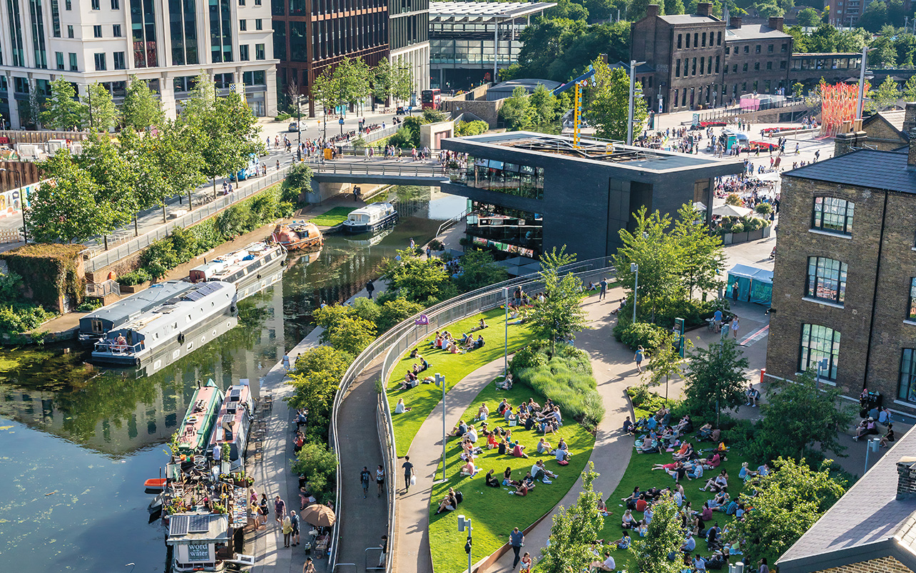
From hard edges to public life: lessons from Chicago
One of the strongest examples of this transformation is Chicago. Once a heavily polluted industrial corridor, the Chicago River has undergone decades of restoration and now serves as a celebrated civic spine. Reversed in the 1800s to protect Lake Michigan, the river long functioned as a working drain for industrial growth. But sustained public and private efforts have shifted its role entirely.
Initiatives like the Chicago Riverwalk and the Wild Mile have opened previously inaccessible edges, turning them into active public places and environmental corridors. The Riverwalk now connects walking and cycling paths with dining, events and public gathering. Further upstream, the Wild Mile and the Lincoln Yards precinct bring floating parks and public open space into a formerly neglected industrial zone.
Led by organisations such as Friends of the Chicago River and Openlands, this work puts access, biodiversity and long-term public value at the centre. It shows how reinvestment in degraded riverfront land can catalyse both community life and new forms of development, including housing and jobs.
Pittsburgh: a strategy built on patience and partnership
Pittsburgh offers another long-term model. Since 1999, Riverlife has coordinated property owners, developers, community groups and government agencies to reshape the city’s relationship with its rivers.
By focusing on ecological restoration, softening waterfront edges and building a connected network of public trails, Riverlife has transformed post-industrial sites into some of Pittsburgh’s most desirable addresses. The result? Over $4 billion in adjacent development and a clear demonstration that investment in riverfront amenity drives value.
But Riverlife also reminds us that this work takes time, policy support and constant negotiation. And while the physical outcomes are impressive, questions around equity, displacement and inclusion remain ongoing challenges.
A site-by-site approach to urban riverfronts
Industrial land is essential to the functioning of our cities, and employment sites in the right locations should be protected. But rather than applying a blanket rule, we need a more nuanced, site-by-site approach.
Do all industrial sites along our urban rivers still deliver the greatest benefit to the city? Could light industrial uses be integrated with innovative housing and mixed-use development in key locations?
Decisions should consider each site’s context and its potential to maximise social, economic and civic value, rather than leaving valuable riverfront land locked away from public use.
Gowanus: housing at the heart of transformation
Gowanus, Brooklyn, is a notable example of adaptive change, where one of the most polluted waterways in New York and its surrounding precinct have become the focus of a new, mixed-use urban vision.
In the 19th and early 20th centuries, the area was home to coal gas plants, shipbuilding, tanneries, chemical plants, paper mills, and slaughterhouses, all relying on the Gowanus Canal for transport and waste disposal. As domestic shipping declined and environmental regulations tightened, the canal’s role as an industrial artery became obsolete.
In 2021, the city rezoned more than 80 blocks, enabling new housing – including affordable and mixed-income dwellings – public spaces, creative industries, and upgraded infrastructure. While remediation of the canal is ongoing, its role in the city’s fabric is shifting, anchoring a more liveable, connected and inclusive future.
This is exactly the kind of bold decision-making our cities in Australia need, where post-industrial land is understood not as a liability, but as the key to unlocking new urban possibilities.
Missed waterfront opportunities in Australia
The failure to reimagine and rezone inner-urban riverfronts is not a theoretical problem, it is playing out in real time across Australian cities.
In Melbourne, the Yarra River corridor at Abbotsford remains one of the most underutilised stretches of urban waterfront. Despite its potential as a prime residential and public realm asset, the area is fragmented, degraded and lacking coordinated restoration efforts. The ambitious Greenline proposal has stalled[1], and there has been little political or planning momentum to deliver the kind of transformation the site deserves.
In Sydney, the Lane Cove River at Lane Cove North presents a similar case. Industrial zoning continues to dominate the waterfront despite growing pressure for housing. A recent proposal for 86 units of social housing was met with fierce local opposition[2] and attempts to rezone the land have struggled to gain support, despite the escalating housing crisis.
Further west, in Adelaide’s inner suburb of Torrensville, the River Torrens runs through an area earmarked for change – but only tentatively. The precinct’s plans suggest modest density increases yet fail to fully integrate with transport networks or provide meaningful community infrastructure. Earlier efforts to rezone parts of the corridor were met with public backlash, particularly regarding the perceived loss of parkland, limiting the scope of renewal.[3]
Will we rise to the challenge?
Across Australia and beyond, the reluctance to act decisively is more than a missed opportunity, it’s a failure to meet the demands of contemporary urban life.
The housing crisis is deepening, and the climate crisis is escalating. Industrial riverfronts offer a rare chance to address both by unlocking land for homes, improving urban resilience, and restoring public and ecological value.
But this cannot be solved through piecemeal rezoning or isolated design moves. We need coordinated leadership, long-term thinking, and community trust. With vision, faith and collaboration we can transform these overlooked edges into places of life, culture, and inclusive growth.
Reclaiming the river is not just renewal, it is a chance to rebalance our cities and rethink who they serve.
Back